Garmany
-
Quite the educational resource! http://mapsnworld.com/germany/where-is-germany.html
-
Of course:
http://www.yelp.com/biz/garmany-red-bank
(and my favorite)
Garmany & Carden Funeral Directors, Inc. : Rosenberg, Texas (TX)

Garmany & Carden Funeral Directors, Inc. | A Tradition of Family Service Since 1865
disclaimer: none of these are actually located in the area highlighted on the map.
-
Here's all the things I could find wrong with that map:
- Sudan is still in one piece
- "Faeroe Islands" and "Western Sharah" are misspelled
- China has taken over Kyrgyzstan and Tajikistan
- Russia has taken over Georgia
- The latitude lines are way off (Mexico is not anywhere near the equator)
- Perhaps in compensation for the above, Eastern Antarctica has advanced aggressively north, swallowing up Heard Island and most of the southern Indian Ocean
Whee!
-
@Thrillho said:
Not strictly wrong, but I'm impressed that they managed to colour several sets of adjacent countries the same colour (most notable example: Turkey, Iraq, Saudi Arabia, Yemen), while still using more than the required minimum four colours (some countries even get gradients!).Here's all the things I could find wrong with that map:
-
I'm from the USA so: seems legit.
-
@Thrillho said:
Perhaps in compensation for the above, Eastern Antarctica has advanced aggressively north, swallowing up Heard Island and most of the southern Indian Ocean
It appears to have broken up into large ice shelves with clear water in-between. In global-warming terms, we're all fucked.What I really like is how the map is using several different projections at once. That's got whole levels of wrong that aren't merely Error'd-bait (or just plain dated).
-
I didn't know I lived in Austrailia, so thanks for that.
-
That was the first thing that caught my eye: Argentina and the U.S. get the special gradient status. The Sun Shines on America, I guess...
-
If it's going to happen to anybody, it's not surprising that Germany would be the victim. The English call them German, the Italians call them Tedesci, the French call them Allemande, the Russians call them Nemetski, and they call themselves Deutsch. I'm willing to let a slight spelling difference pass, but that's just messed up.
-
@da Doctah said:
The English call them German, the Italians call them Tedesci, the French call them Allemande, the Russians call them Nemetski, and they call themselves Deutsch.
And the Dutch call them Duits.
-
<title>Germany Flag</title>
This is all I have to add.Edit: I was wrong.
<img src="/flags/bosnia.gif" alt="Bosnia Harzegovina" width="50" height="33"><img src="/flags/bulgaria-flag.gif" alt="Bilgaria" width="50" height="33">Bulgaria</a>
<img src="/flags/czech-republic-flag.gif" alt="Czeh Republic" width="50" height="33">Czech Republic</a>
But who cares about alt attribures, right?<img src="/flags/united-kingdom.gif" alt="United Kingdom - uK" width="50" height="25">United kingdom</a>
And of course:
<a href="/yugoslavia/index.html"><img src="/flags/yugoslavia.gif" alt="Yugoslavia" width="50" height="32">Yugoslavia</a>
-
@Zecc said:
And of course:
Wow, I think that the linked map shows how Yugoslavia looked before the 2nd World War...<a href="/yugoslavia/index.html"><img src="/flags/yugoslavia.gif" alt="Yugoslavia" width="50" height="32">Yugoslavia</a>
-
-
Hungary is not in UTC+8 (rather UTC+1)
Also this sentence: Hungry was introduced to the so-called "Goulash Communism". Hungry and Hungary often gets mixed intentionally by semi-funny tourists thinking noone thought of this before, but in this case it seems to be a mistake like the rest.
Nice to see that they took the time to research and list the major political parties and their leaders too, but seems they forgot that these things tend to change here quite often.
Bonus fun fact: The "Hungary" link in the upper left corner leads to the nonexistent "http://mapsnworld.com/hungary/finland.html" page.
-
@Thrillho said:
Here's all the things I could find wrong with that map:
...
- The latitude lines are way off (Mexico is not anywhere near the equator)
- Perhaps in compensation for the above, Eastern Antarctica has advanced aggressively north, swallowing up Heard Island and most of the southern Indian Ocean
Maybe it's just me, but the map looks a bit distorted. Greenland looks a bit too large. It's almost like they to a standard rectanglar map of the world and just cut out a circle of it, then drew curved longitude lines on to try and make it look right. If that's what happened, it would explain the latitude lines being off as well.
Some other things I noticed when I clicked on the North America link:
- Greenland (apparently) doesn't have a flag
- The src attributes for the Dominican Republic and Puerto Rico flag images appear to be broken
- Puerto Rico and the US Virgin Island are listed as seperate countries, even though they are US territories
- Apparently I live in the United Staes of America
Out of curiosity, I clicked through on the United Staes of America, and found that all the links at the top have to do with Alabama. So much for the other 49 staes.
-
@Zecc said:
But who cares about alt attribures, right?
Muphry's law strikes again. ._.
-
-
@Ill Stew said:
Apparently, in addition to teaching geography, they also prepare chicken products in very higienic way.Quite the educational resource! http://mapsnworld.com/germany/where-is-germany.html
-
@Ill Stew said:
Quite the educational resource! http://mapsnworld.com/germany/where-is-germany.html
Their home page is also a bit pathetic. For example, there's a bit of pseudo-legalese (that underlines on mouseover despite not being a link) that indicates quite clearly that no legally-trained individual has ever given real advice.@the site said:All contents and images on the site are protected by © law of United States and may not be use for any purpose, without permission
-
@dkf said:
@the site said:
All contents and images on the site are protected by © law of United States and may not be use for any purpose, without permission
But... But... How did you read that without permission?
-
@levbor said:
Croatia is not a Balkan state
Croatia might not be, but Australia is, at least according to that link.
-
@levbor said:
<font color="#698d73">Croatia is not a Balkan state</font>
I like how the map that link brings up was clearly colored after the text was added. And then all the text in the legend doesn't even fit the layout there. In some ways, that map looks like a half-assed sixth grade project done in an old version of MS Paint.
-
@ender said:
@levbor said:
Croatia is not a Balkan state
Croatia might not be, but Australia is, at least according to that link.Funny, I don't see Autralia in that map ...
Even funnier, the link in their list actually goes to the page for Australia.
Reminds me of a shirt I got when visiting my sister in Austria. It said, "There are no kangaroos in Austria." I got so many people telling me I was an idiot for wearing that shirt. Then I'd read it to them, and they'd get an "Oh shit, I'm a moron" look and walk away.
-
So I went a bit deeper than I should have into that site...
http://www.mapsnworld.com/geographical-symbol.html
http://www.mapsnworld.com/america/where-is-alabama.html (no, they don't have this for any other state)
Waanshington is the capital of America but not the United States, the Dominican Republic doesn't exist, North Korea starts with N and South Korea starts with K, and Howland Island is a country.
-
To sum up:
The site was done in MS paint as a school project in goegraphy by the sixth-grader son of a higienic Indian butcher. If his classmates decide to use it without permission, it will count as plagiarsim.
-
Well, I certainly learned some new things about the UK.
Sadly, there isn't much to see regarding the British Vrgine Island, but at least we now know that the Isle of Wight is a city...
-
The phrase "Eastern Antarctica" used in this thread boggles my mind somewhat, too. It's like saying "Clockwise Antarctica".
-
I enjoyed the list of zip codes for all countries.
-
@El_Heffe said:
I enjoyed the list of zip codes for all countries.
If you click on the link for USA, you get the Zip Code All States of America. As with other pages for the US, they only seem to care about Alabama. I'm willing to bet the creator lives in Alabama.
-
Ok, I was going to let the thread go longer, but you guys do realize this is a joke site, right? Please God tell me you realize it's a joke site.
Actually digging in... maybe it's not. Poe's Law is strongly in-play here. Disregard.
-
@abarker said:
@El_Heffe said:
I enjoyed the list of zip codes for all countries.
If you click on the link for USA, you get the Zip Code All States of America. As with other pages for the US, they only seem to care about Alabama. I'm willing to bet the creator lives in Alabama.
I'm guessing New Delhi, India:
Registrant Name: Z Alam Registrant Organization: Zaa Covers Registrant Street: Delhi New Delhi Registrant City: new delhi Registrant State/Province: Delhi Registrant Postal Code: 110006 Registrant Country: IN Registrant Phone: +91.9811944782 Registrant Phone Ext: Registrant Fax: Registrant Fax Ext: Registrant Email: zaa_covers@yahoo.com
-
@abarker said:
As with other pages for the US, they only seem to care about Alabama. I'm willing to bet the creator lives in Alabama.
The perpetrator appears, from both cues in the content and domain registration, to live in India. Most likely, Alabama is alphabetically first among US states, so they started there and never (yet?) got any further. (Although the terrible grammar and utter ignorance of geography would be consistent with living in Alabama, or anywhere else subject to the US public non-education system.)
-
@abarker said:
@El_Heffe said:
Even better, the list of zip codes for all countries (ignoring the fact that no country other than the U.S. has zip codes) lists several things that are not countries such as Africa and Arctic Ocean.I enjoyed the list of zip codes for all countries.
If you click on the link for USA, you get the Zip Code All States of America. As with other pages for the US, they only seem to care about Alabama. I'm willing to bet the creator lives in Alabama.
-
@El_Heffe said:
Even better, the list of zip codes for all countries (ignoring the fact that no country other than the U.S. has zip codes) lists several things that are not countries such as Africa and Arctic Ocean.
The creator seems to know that only the US has ZIP Codes™. You will notice that, in that list, USA is the only country (or non-country region) that links to a page describing its ZIP Codes™.
-
@HardwareGeek said:
Then why bother to have a page of "zip codes of all countries"?@El_Heffe said:
Even better, the list of zip codes for all countries (ignoring the fact that no country other than the U.S. has zip codes) lists several things that are not countries such as Africa and Arctic Ocean.
The creator seems to know that only the US has ZIP Codes™. You will notice that, in that list, USA is the only country (or non-country region) that links to a page describing its ZIP Codes™.
-
-
@El_Heffe said:
Then why bother to have a page of "zip codes of all countries"?
Why bother to have any of the pages?
-
This is ironic because the Garmins make the best sat nav.
-
@blakeyrat said:
Ok, I was going to let the thread go longer, but you guys do realize this is a joke site, right? Please God tell me you realize it's a joke site.
I'm of the opinion that it's a really bad site that was not intended as a joke, but it may yet inspire the creation of an actual joke site where everything is just a little askew. I'm thinking along the lines of a book I picked up some years ago entitled Giraffes? Giraffes! in which the author (and her apparently feeble-minded husband) tell all there is to know about giraffes, including the fact that they're most common in Terre Haute, Indiana, to which they emigrated from their original home on the planet Uranus via a giant escalator.Actually digging in... maybe it's not. Poe's Law is strongly in-play here. Disregard.
-
@Tiggrrr42 said:
Isle of Wight is a city
Priceless. But look carefully, I think you mean the Isle of Wright?
-
@Zagyg said:
@Tiggrrr42 said:
Yes, people get that confused with the Wight Brothers.Isle of Wight is a city
Priceless. But look carefully, I think you mean the Isle of Wright?
-
@blakeyrat said:
Ok, I was going to let the thread go longer, but you guys do realize this is a joke site, right? Please God tell me you realize it's a joke site.
Actually digging in... maybe it's not. Poe's Law is strongly in-play here. Disregard.
Sadly, I'm pretty sure it is intended to be real. In any case, other people have certainly thought it's real. Examiner.com is certainly not in the upper eschelon of reliable news sites (specifically, it's a content farm with essentially zero editorial oversight), but mapsnworld's map of Libya got used there to illustrate a geopolitical story. Some of that map is even accurate, and some of the oddities are marginally-accepted variant spellings of Libyan cities, such as Surt for Sirte. On the other hand, Awjilah (misspelled on the map) is a tiny town of less than 7000 people, hardly the equal of regional capitals or trade centers. Waha's not a settlement of any size; it's an oil field. And I can't find anything corresponding to Waw Al Kabir.
-
Had anyone tried clicking on the photo link yet? There's some more fun stuff there:
- Riding ob [sic] the train in San Francisco
- The Grand Canions [sic] of Arizona. And after living in Arizona for years, I only thought we had one!
- Some random mueseum in Alaska
- This picture of @the site said:
... beautiful canada, with green fields.
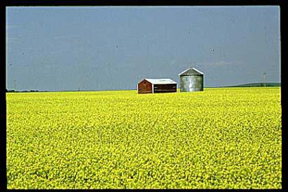
Apparently green looks different in Canada.
-
@abarker said:
- This picture of @the site said:
... beautiful canada, with green fields.
Apparently green looks different in Canada.
Looks green to me.
- This picture of @the site said:
-
@abarker said:
Had anyone tried clicking on the photo link yet? There's some more fun stuff there:
- This picture of @the site said:
... beautiful canada, with green fields.
Apparently green looks different in Canada.

- This picture of @the site said:
-
@Snooder said:
@abarker said:
- This picture of @the site said:
... beautiful canada, with green fields.
Apparently green looks different in Canada.
Looks green to me.Sure you aren't color blind? Or maybe your monitor needs adjusting? I've checked on two different systems, and asked a couple other people. That is yellow.
- This picture of @the site said:
-
@abarker said:
@Snooder said:
@abarker said:
- This picture of @the site said:
... beautiful canada, with green fields.
Apparently green looks different in Canada.
Looks green to me.Sure you aren't color blind? Or maybe your monitor needs adjusting? I've checked on two different systems, and asked a couple other people. That is yellow.
The top half is blue, and the bottom half is yellow. Those definitely add up to green.
- This picture of @the site said:
-
@Buttembly Coder said:
The top half is blue, and the bottom half is yellow. Those definitely add up to green.
Not on a monitor!
-
For the purpose of science, I resized the image down to 1x1 in Paint.NET, then grabbed the color with the eyedropper. The result is this RGB(141,158,93), which looks like an olive drab green to me.
-
@abarker said:
- Some random mueseum in Alaska
I'm wondering why they picked a picture of Palmer for doing an image of Alaska. You would think that doing something of mountains or ice and snow or of a remote villiage would be the pick, not the visitor center of what is basically a bedroom community for the only city in the state.